


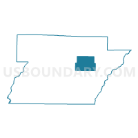
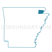
Friendship Voting District, Greene County, Arkansas
About
Outline

Summary
| Unique Area Identifier | 526568 |
| Name | Friendship Voting District |
| County | Greene County |
| State | Arkansas |
| Area (square miles) | 23.82 |
| Land Area (square miles) | 23.78 |
| Water Area (square miles) | 0.04 |
| % of Land Area | 99.84 |
| % of Water Area | 0.16 |
| Latitude of the Internal Point | 36.14065190 |
| Longtitude of the Internal Point | -90.43923090 |
Maps

Graphs
Select a template below for downloading or customizing gragh for Friendship Voting District, Greene County, Arkansas


Neighbors
Neighoring Voting District (by Name) Neighboring Voting District on the Map
- Clark Voting District, Greene County, AR
- Hurricane Voting District, Greene County, AR
- Lake Voting District, Greene County, AR
- Oak Grove/Union Voting District, Greene County, AR
- Reynolds Voting District, Greene County, AR
- Union Voting District, Greene County, AR
Top 10 Neighboring County Subdivision (by Population) Neighboring County Subdivision on the Map
- Clark township, Greene County, AR (19,443)
- Union township, Greene County, AR (2,587)
- Hurricane township, Greene County, AR (1,685)
- Friendship township, Greene County, AR (822)
- Lake township, Greene County, AR (205)
- Reynolds township, Greene County, AR (98)
Top 10 Neighboring Place (by Population) Neighboring Place on the Map
Top 10 Neighboring Unified School District (by Population) Neighboring Unified School District on the Map
- Paragould School District, AR (20,123)
- Greene County Technical School District, AR (18,658)
- Marmaduke School District, AR (3,835)